Why don't you go to Peru?
I hope that they still remember from school where Peru is located? No, not so - the Republic of Peru! The Republic of Peru is located in the Western part of South America, on the central-western coast. And its neighbors, 5 countries: Ecuador (Northwest), Colombia (North), Brazil (East), Bolivia (Southeast), Chile (South). Well, the SIXTH border is the western, Pacific Ocean.
And also the area:
Peru can be divided into three belts:
- The Pacific coast is called Costa. The northern part of the Sechura desert, the southern part of the Atacama.
- Further inland to the east, from north to south, the Andes (Cordillera) mountains stretch with numerous peaks above 6000 m. The highest point in Peru is Mount Huascaran (6768 meters). This belt is called the Sierra.
- Further east is the Selva belt. This is the Amazonian lowland with tropical rainforests.
The presence of these belts make the climate (weather) in Peru very unusual! See below.
Or so:
- Northern, Central and Southern regions.
- Administratively, Peru has 25 regions.
And how to get there?
From neighboring countries, everything is simple. And for those who will fly by plane from distant countries, you will be met by Jorge Chavez International Airport, in the capital of Peru, Lima. This airport is also: the main hub for local flights and provides services for the rental of light aircraft.
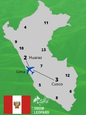
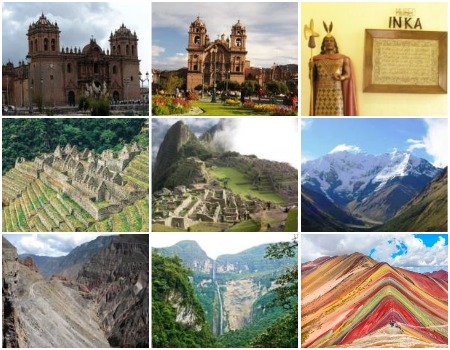
Schematic map of interesting areas of Peru by interests
Why do we even need to come here?
And so it is clear what is there: the ocean, rivers, waterfalls, lakes, forests, mountains, historical places, etc.
And here the most USEFUL information begins.
Before the trip, you must decide what you want: an active (extreme) vacation or light walks (excursions).
If you are interested:
- First, these are mountains for climbing and beautiful multi-day trekking.
So you need to go to the Huaraz area (number 2 on the map)
- Secondly, these are easy - medium difficulty trekking, as well as excursions in the Cusco area (number 3 on the map):
Machu Picchu, Rainbow Mountain, etc.
- Third, sightseeing trips to other places (all other numbers, transcript below).
1. Since you are on the EXTREMETOUR website, we start with extreme and active recreation.
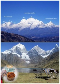
Number 2 on the map, Ancash region, the administrative center of the city of Huaraz. Well, let's go...
The city of Huaraz is the capital of the department of Ancash. It is located:
- at an altitude of about 3000 meters above sea level
- north of Lima city
- the distance between cities is about 400 km, the Panama Highway passes through the city, the longest highway in the world.
You can get to the city by plane, the flight time is about 40 minutes. We note right away that if you do not have acclimatization or you do not tolerate altitude well, we recommend you the second way - transfer by bus about 8 hours (there are convenient night flights with sleeping places).
Huaraz, tourist and cultural center. Place of active recreation: mountaineering, hiking (trekking), excursions to beautiful places and historical monuments (be sure to check out the Catholic Cathedral of San Sebastian and the Archaeological Museum). Economic activity is actively conducted and developed here, agriculture, trade, etc. are developing.
Near the city there are many mountain lakes (lagoons) and beautiful peaks in the mountain ranges of Cordillera Blanca, Cordillera Huayhuash, etc. There are many hotels and restaurants here. Very tasty local cuisine. The population of the city is about 150 thousand people.
STOP!!! We forgot about the WEATHER, and this is very important!!!
We remind you right now. If you have a cold winter in the Northern Hemisphere, December - January, then it is summer in Peru. But! As noted earlier, the climate and weather in this wonderful country are very peculiar and bizarre. Somewhere hot, and somewhere cold, cool and damp. In this regard, in each section, we will briefly write the best time interval for trips. Read the full WEATHER information at the end of this post.
The mountain system in Peru is the Andes, here they are also called the Cordillera. And that's not all, there are: Cordillera Blanca, Cordillera Vilcabamba, Cordillera de Vilcanota, Cordillera de Carabaya, Cordillera Negra and Cordillera Huayhuash.
Accordingly, there must be very interesting peaks and trekking. And they really are.
MOUNTAINEERING
This area (the Huaraz area, number 2 on the map) is a mountaineering paradise, even though there are no peaks higher than 7000 meters.
WEATHER. The best time for mountaineering is June - August. December-January, you can climb up to a maximum of 5000 meters.
But here is:
- more than 30 peaks higher than 6000 m,
- N number of interesting peaks below,
- Alpamayo peak (5974 m), "The most beautiful mountain peak in the world", Alpinismus magazine, 1966
- Artesonrahu summit (6025 m), Paramount Pictures Corporation uses the image of this peak in the logo of its products
- handsome Huascaran (6768 m), the highest point in Peru and the fourth highest mountain in South America.
- panoramic peak of Pisco (sometimes called Nevado Pisco). This is a two-peak mountain in Peru, about 5752 meters high. From its summit one can enjoy the most panoramic and picturesque views of the highlands in Peru. It is known as the NATURAL viewpoint or Cordillera Blanca Balcony.
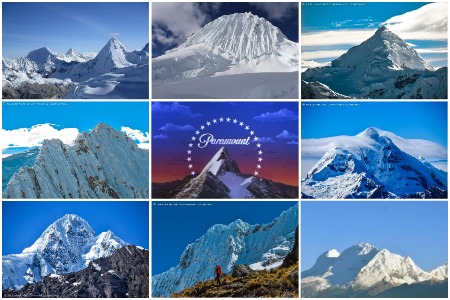
Well, very beautiful mountains in Peru
Here is a short list of the most popular peaks and their combinations for climbing, as well as the duration of the tour in two areas.
Cordillera Blanca area:
- Huascaran, 6768 m (10 days)
- Chopikalki, 6354 m (5 days)
- Kopa, 6188 m (4 days)
- Kitaraju, 6040 m (8 days)
- Tokyaraju, 6034 m (5 days)
- Artesonraju, 6025 m (5 days)
- Alpamayo, 5947 m (8 days)
- Nevado Pisco, 5752 m (6 days)
- Vallunaraju, 5686 m (3 days)
- Miruraju, 5688 m (4 days)
- Ishinca, 5530 m (3 days)
- Nevado Yanapakcha, 5460 m (3 days)
- Urus, 5423 m (4 days)
- Maparaju, 5326 m (3 days)
- Huapi, 5421 m (3 days)
- Kajap, 5230 m (3 days)
- Mateo, 5190m (1 day)
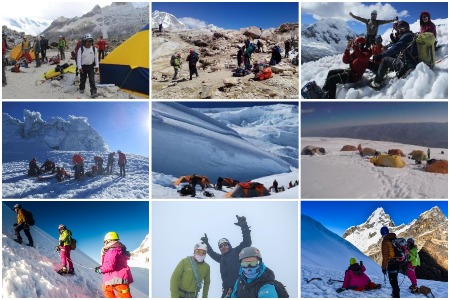
Photos from climbing and approaches to the peaks
Popular combinations:
- Alpamayo + Kitaraju (12 days)
- Vallunaraju + Nevado Pisco (10 days)
- Nevado Yanapakcha + Chopikalki (8 days)
- Nevado Pisco + Huascaran (14 days)
- Ishinсa + Urus (4 days)
- Nevado Pisco + Chopicalki (8 days)
- Alpamayo + Huascaran (15 days)
- Alpamayo + Kitaraju + Artesonraju (18 days)
- Nevado Pisco + Ishinca + Toclaraju (14 days)
- Urus + Ishinca + Tokyaraju (10 days)
Cordillera Huayhuas area:
- Pumarinri, 5465 m (8 days)
- Diablo Mudo, 5427 m (5 days)
- Pumarinri, 5465 m + Diablo Mudo, 5427 m (17 days)
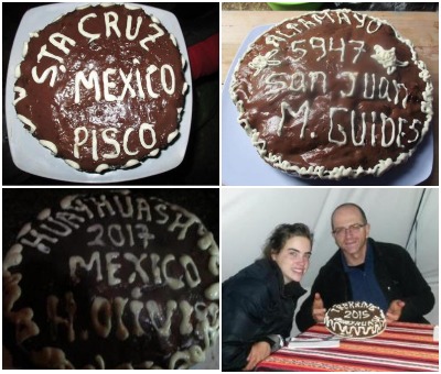
As a nice bonus after climbing
Attention! Before the trip, pay attention to the tour programs, especially combinations. You may need an additional 1-2 days in advance.
Recommended climbing programs - view
MULTI-DAY TREKKINGS AND TREKKING WITH CLIMBING
WEATHER
In the Huaraz area - The best time for trekking is May - September. Part of the trekking (short routes) can be walked in December - January.
Climbing trekking
Cordillera Blanca area:
- Santa Cruz with the climbing Nevado Pisco (5752 m), 9-11 days
- Climbing Santa Cruz: Pisco (5752 m) and Chopicalqui (6354 m)*, 14 days
- Alpamayo Cedros with theclimbing Ishinca (5560 m), 15 days
Cordillera Huayhuas area:
- Trekking in the Cordillera Huayhuash with the climbing peaks of Pumarinri (5465 m) and Diablo Mudo (5427 m), 17 days.
Or maybe coffee with such views?
Trekking
Attention! The height of the passes is in the range from 4600 to 5100 meters!
Cordillera Blanca area:
- Cedros, Alpamayo, Vaqueria (12 days)
- Cedros, Alpamayo, Ulta (15 days)
- Alpamayo base camp (10 days)
- Santa Cruz, Classic trekking, (7 days)
- Santa Cruz of Lake Llanganuco (5 days)
- Santa Cruz, Vaqueria, Llanganuco Lakes (5 days)
- Santa Cruz, Ulta (7 days)
- Olleros, Chavin de Huantar (4 days), complex of archaeological sites
- Pastoruri Glacier, Chavin de Huantar (4 days)
- Quilkayhuanca River, Cojup Valley (3 days)
- River Quilkayhuanca, Cojup, Ishinca (5 days)
- Olleros, Carhuascancha Valley, Chavin de Huantar (6 days)
- Valleys of Quebrada Quillquihuanca and Quebrada Quilling 3 days
- To Pisco Base Camp, Lake 69, Llanganuco Lakes (3 days)
- Llanganuco lakes, lagoon 69, 3 days
- Trekking in the Ishinca Valley, Don Bosco refugio in Los Andes (3 days)
- Keshke Valley - Pamparaju Lake Trek (2 days)
- Quilkayhuanca Valley (2 days)
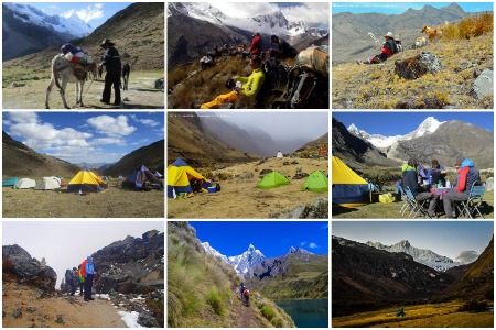
Here in such wonderful places our trekking takes place
Cordillera Huayhuas area:
- Trekking Queropalca, Llamak (10 days)
- Classic trekking Cordillera Huayhuash (11-15 days)
- To Siula Peak Base Camp (13-15 days)
- To the lakes of Siula (12 days)
- Vikong Thermal Baths and Kuyok Pass (9 days)
- Through the Trapezio Pass (8-9 days)
- To Jahuacocha lagoon (4-5) days
- Queropalca area (7 days)
- "Touching the void", to the peaks of Yerupaja (6640 m) and Siula Grande (6344 m), 10-12 days
- Alpine route to the Cordillera Huayhuas (10 days)
- Huayhuas trekking to Churin town (Cordillera Raura) via Sura Saka Lagoon (7 days)
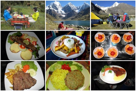
You asked about food on climbing and trekking, see for yourself
One-day trekking, walks, trips
Attention! Many lakes (lagoons) and other places are at altitudes from 3800 to 4500 meters!
- Mallaca Lake
- Lake Churup
- Lake 69
- Lake Llaca
- Lake Shallap
- Lake Rajucolta
- Lake Vilcacocha
- Lake Paron
- Lake Hidden Urus
- Lake Ahuac
- Lake Uruscocha and Honcopampa
- Lake Llanganuco and Portachuelo Viewpoint
- Pastoruri Glacier
- Llaca valley and Ranrapalca glacier
- Quillqueyhuanca Valley
- Cordillera Negra
- Ruins of Wilcahuain
- Marian village
- Huaraz ranges, panoramic views
- Macashca Hill
- Rock forest Hatun Machay
- Honcopampa and Chancos (thermal baths)
- Chavin de Huantar (archaeological site complex)
Recommended best trekking - view
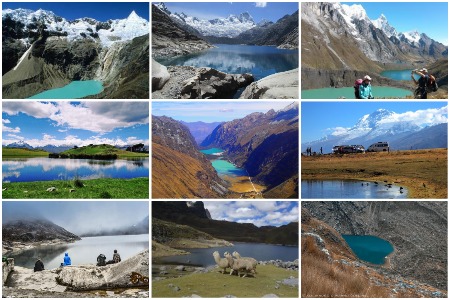
Here are such beautiful lagoons, lakes
2. The next area for those who like more comfort is easy and medium difficulty trekking and excursions in the Cusco city area (number 3 on the map): Sacred Valley, Machu Picchu, Rainbow Mountain, more difficult Ausangate (6385 m) and others excursions
CUSCO - a city with a great centuries-old history, is the administrative center of the Cusco region of the same name.
- located in the southeast of Lima, at a distance of about 600 kilometers in a straight line (by plane), and a little more than 1000 kilometers by road.
- the population of the city is currently about 500 thousand people
- located about 3400 meters above sea level, located in the Andes
- founded by the Incas and for a long time was the capital of the great Inca empire
- in 1533, the Spanish conquerors came to the city. From this time began the Spanish period
Who is coming here?
- First of all, people who are interested in the history and culture of the Incas, the architecture of the city itself. The city has many historical and archaeological monuments and architecture of the Spanish period, museums, cathedrals, etc.
- Tourists who are interested in trekking to the Sacred Valley, to Machu Picchu, to the Rainbow Mountains and beautiful trekking in the Andes.
WEATHER. The weather here is more stable but changeable (rainy), but some tours can be done all year round*. See below.
Trekking with ascents in the Cusco area:
Recommended season June-September
- Classic trek, climbing the peaks: Campo I (5350 m) and Ausangate (6385 m), 10 days
Trekking in the Cusco area:
Attention! When choosing your track, pay attention to the height of the passes. There are routes with a height of passes of the order of 4000 to 4600 meters
Recommended season May-September
- Machu Picchu Short Inca Trail (2 days)
- Machu Picchu classic trekking (4 days)
- Machu Picchu via Salkantay (5 days)*
- Machu Picchu via Choquequirao (5 days)
- Inca Trail, Machu Picchu, Vinicunca (8-13 days)
- Trekking through the Lares Valley to Machu Picchu (3-4 days)
- Trekking Vilcabamba to Machu Picchu (5 days)
- Trekking Choquequirao (4 days)
- Trekking Choquequirao, Salkantay, Machu Picchu (9 days)*
- Trekking Choquequirao and Huanipaca (5 days)
- Machu Picchu, Vinicunca (4 days)
- Peru's Best: Coast & Andes (9 days)
- Machu Picchu and Amazon Adventure (10 days)
- Trekking in the Ausangate mountain range (4-6 days)
- Trekking Ancascocha, Machu Picchu (5 days)
- Salkantay, Lake Humantay, Eco-camp (3 days)
- Vinicunca (Rainbow or Colored Mountains), 1 day
- Machu Picchu and Galapagos (11 days)
- Umantai Lagoon (1 day)
- Huacachina Oasis (1 day)
Cusco city, surroundings and other interesting places in Peru
3. Excursion trips to other places of interest (all other figures)
1. Chachapoyas district, Amazonas region, Chachapoyas city (map number 4)
- Discover Chachapoyas (4-6 days)
- Chachapoyas, Gokta waterfall (4-6 days)
- Secrets of the Chachapoyas tour (6-8 days)
- Hike to the tombs and citadels of Chachapoyas (7 days)
- Archaeological and forest tour of Northern Peru (8 days)
- Amazon and Andes of northern Peru (8 days)
- Condor Lake (7 days)
- Adventures in northern peru (14 days)
2. Huaytapallan District, Junin Region, Huancayo Province, (map number 7)
- Trekking in the area of the Huaytapallana mountain range (5-6 days)
3. District of the city of Arequipa, region of Arequipa (map number 8)
- Cotahuasi Canyon (4-10 days)
4. Districts of the cities of Ica and Pisco, Ica region (map number 5)
- Nazca Desert (Nazca Plateau)
- Oasis of Huacachina
- Andean Candelabra (Pisco City)
5. District of the city of Puno, Puno region (map number 6)
- Lake Titicaca
- Uros floating islands
- Tiwanaku Ancient City (UNESCO World Heritage Site)
6. District of the city of Chiclayo, Lambaeque region (map number 9)
- Valley of the Pyramids Tucume
7. Territories of the regions of Madre de Dios and Cusco, (map number 3)
- Manu National Park
- Ancient Fortress of Saxuaman
- Salt mines of the city of Maras
8. District of the city of Trujillo, La Libertad region (map number 10)
- Ancient city of Chan Chan
9. Peruvian Amazonia (map number 11, 12 and 13).
As it was written earlier, it is called - Selva. It is located in different regions of Peru, but there are three:
- Iquitos city, Loreto region
- city of Puerto Maldonado (gateway to Manu National Park), Madre de Dios region
- Tambopata Province, Madre de Dios Region
In the high-altitude forests of the Huanuco region, there is a unique river. It is called: Deadly, Boiling River or Shanai-Timpishka (number 13 on the map).
Visit the wild Amazonia and you will have an unforgettable experience of a lifetime!!
For those who are interested in a trip to Peru, our Peruvian office will do everything to make you enjoy it as much as possible!
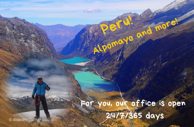
Our office operates on the principle of 24/7/365 days a year.
Before the trip, do not forget about:
- First aid kit for trekking, hiking, climbing - View
- Personal clothes and shoes - View
- Personal and group equipment - View
WEATHER
Well, here is the promised information about the climate and weather in Peru.
Writing information is not so easy, because here at different times of the year there are both rainy and dry seasons, and the weather in different areas is very different.
And so, let's go. Several factors influence the climate and weather in different regions of Peru.
From the Peruvian side:
- Pacific currents. On the northern coast it is cold, on the central and southern coast it is warm.
- The height of the mountain barrier (Andes).
- Warm and humid Amazonia, beyond the Andes in the east of the country (equatorially humid climate).
From the Brazilian and Bolivian sides:
- Brazilian - warm current of the Atlantic Ocean (South Equatorial Current).
- Warm and humid Amazonia (equatorial humid climate), western part of the country.
All this sets the air masses in motion towards the mountain barrier from two sides. The cold sea current reduces the amount of precipitation in the west of the country, and the Andes mountain range, as a barrier up to 6000 m, does not allow moisture to pass from the east, the Selva region.
COSTA
The climate here is semi-tropical in the north and subtropical in the center and south. The average annual temperature is from 18 to 24 C.
- December - April (summer period) is hot and dry here. Precipitation is very rare. During the day, the temperature is from 26 C in the south and up to 36 C in the north. At night around 20-24 C. Good time to relax on the Peruvian coast.
- June - August (winter period) daily air temperatures in the region of 19 C in the south and up to 28 C in the north. At night around 12-18 C.
Attention! In fact, recreation in this area is possible all year round.
SIERRA
But in the mountainous region of the Andes, especially in the summer (December - February), at altitudes above 5000 meters everything is covered with ice and adhering snow, it becomes windy, visibility is very often poor, white milk. At altitudes around 4000 m, frosts sometimes occur at night.
- From December to April (summer period), altitudes in areas of 3000 - 4000 meters, daytime temperature in the region of 20 C, and at night it is already cool, in the region of 5 C.
- From June to August (winter period), the daytime temperature is about 17 C, and at night the frost is down to -6 C. Good time for trekking and climbing in the mountains and in the Machu Picchu area.
Rainy season: from January to March, and then starts from September.
Attention! In the Cusco area (trekking to Machu Picchu) are held all year round.
SELVA
It is always hot and humid in the Selva, the climate is tropical humid. Humidity is always around 85-100%!
- December - April (summer period), daytime temperature from 26 to 36 C (south-north), and at night 20-24 C.
- June - September (winter period), daytime temperature from 24 to 30 C (south-north), and at night 18-22 C. A good time to relax in the Amazon.
Rainy time:
- November - March (rainy season). Note that in November, there will be showers from time to time, but they are weaker than in February.
- April is still the rainy season. Therefore, in March-April, it is better to refuse to visit the highlands and the jungle. At this time, there may be difficulties in the mountains and rainforests of the Amazon.
Attention! Some places with good roads and tourist infrastructure can be visited all year round.
And here you can get acquainted with the descriptions of programs in Peru
- Recommended best trekking - View
- Climbing programs - View
If you liked the article, put Like and share with your friends!